News From Nowhere Radical & Community Bookshop
not-for-profit - a workers'co-op - committed to social justice | 96 Bold Street, Liverpool L1 4HY - 0151 708 7270
Knotty Ash and Old Swan 1906. Lancashire Sheet 106.12 (Facsimile of old Ordnance Survey Map)
by Introduction by Kay Parrott - £3.50 Alan Godfrey Maps (1993)
other format
ISBN 13: 9780850546200 | ISBN 10: 0850546206
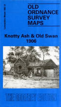
This detailed map covers the area of east Liverpool around Old Swan and Knotty Ash. Coverage stretches from Church Road Stanley eastward to St John's Church Knotty Ash; and from Russian Drive southward to Oak Hill Park.
Features include Knotty Ash, Old Swan Ward, Stoney Croft, Oakhill Park, Old Swan, Stanley (East), Highfield Infirmary, Old Swan Rope Works, Liverpool Cattle Market, tramways, St Oswald's RC church, Derwent Square, Borax Works, Moss Farm, Fir Grove Farm, Cheshire Lines Railway with Knotty Ash & Stanley station, Hebrew Cemetery, Highfield House, Little Bongs, The Old Hall etc. On the reverse we include street directory entries for Green Lane, Leinster Road, Prescot Road, Russian Drive, St Oswald's Street, Sandstone Road, Thomas Lane.
This map links up with sheet 106.12 West Derby to the north, 106.11 Newsham Park to the west, 107.09 Roby to the east, 106.16 Wavertree to the south.
(Price & availability last checked: July 2023)
© News From Nowhere Co-operative Ltd IP24524R 2004-2024 | Privacy policy | Contact | return to top of page