News From Nowhere Radical & Community Bookshop
not-for-profit - a workers'co-op - committed to social justice | 96 Bold Street, Liverpool L1 4HY - 0151 708 7270
Walton on the Hill 1906. Lancashire Sheet 106.03 (Facsimile of old Ordnance Survey Map)
by Introduction by Kay Parrott - £3.50 Alan Godfrey Maps (1997)
other format
ISBN 13: 9780850549355 | ISBN 10: 0850549353
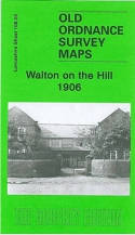
This detailed map covers the eastern part of Walton on the Hill, with coverage stretching from Walton Lane eastward to Strawberry Lane and Scarisbrick House. It was then a largely rural area, but features include much of Liverpool Cemetery, short stretch of LNWR line with Walton & Anfield station, Well Farm, Cheshire Lines Railway with Fazakerley South and West Junctions, Walton Old Lodge, Cherry Lane Farm, New Hall, Stop Gate Farm, Strawberry Farm.
On the reverse we include a selection of street directory entries, incl Cherry Lane, Elm Road, St Mary's Lane and Walton Lane; plus an 1897 railway timetable for the Liverpool Bootle, Alexandra Dock & Southport line.
This map links up with sheet 99.15 Fazakerley to the north, 106.02 Bootle to the west, 106.04 Croxteth Hall to the east and 106.07 Anfield to the south.
(Price & availability last checked: July 2023)
© News From Nowhere Co-operative Ltd IP24524R 2004-2024 | Privacy policy | Contact | return to top of page