News From Nowhere Radical & Community Bookshop
not-for-profit - a workers'co-op - committed to social justice | 96 Bold Street, Liverpool L1 4HY - 0151 708 7270
St Michael's & Aigburth Vale 1908. Lancashire Sheet 113.07 (Facsimile of old Ordnance Survey Map)
by Introduction by Naomi Evetts - £3.50 Alan Godfrey Maps (1990)
other format
ISBN 13: 9780850543636 | ISBN 10: 0850543630
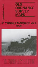
Alan Godfrey have published two versions of this map (1908 and 1924), showing how the area changed across the years.
The maps cover the area of south Liverpool around St Michael's, Aigburth Vale and the southern part of Sefton Park. Coverage stretches from the Jericho Shore eastward to Gladeville Road, and from Livingston Drive southward to Otterspool House.
Features include the western part of Mossley Hill, St Anne's church, tramways, Aigburth Lodge, Otterspool Farm, St Charles RC church, St Augustine's Home, Corporation Engineering Works, Cheshire Lines Railway with Otterspool and St Michael's stations, St Michael's Hamlet, Knott's Hole, West Dingle, Fulwood Park etc.
The maps links up with sheet 113.03 Princes Park to the north, 113.08 Mossley Hill to the east.
(Price & availability last checked: July 2023)
In booklists: Alan Godfrey Maps,
In categories: History & Biography, Local Interest,
© News From Nowhere Co-operative Ltd IP24524R 2004-2024 | Privacy policy | Contact | return to top of page