News From Nowhere Radical & Community Bookshop
not-for-profit - a workers'co-op - committed to social justice | 96 Bold Street, Liverpool L1 4HY - 0151 708 7270
Liverpool (Newsham Park) 1905. Lancashire Sheet 106.11 (Facsimile of old Ordnance Survey Map)
by Introduction by Kay Parrott - £3.50 Alan Godfrey Maps (1991)
other format
ISBN 13: 9780850544534 | ISBN 10: 085054453x
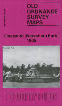
This detailed map and busy map covers the area of north Liverpool around and to the south of Newsham Park.
The map includes the eastern part of Everton, and other districts include Fairfield, Elm Park, Kensington Ward and Low Hill Ward. Coverage stretches from Margaret Street and Aber Street eastward to Silverdale Avenue, and from Rocky Lane southward to Holly Road. The many features include a stretch of the Edge Hill & Bootle line with Stanley and Edge Lane stations, tramways, Sheil Park, Newsham Park, Liverpool Athletic Ground, Electric Power Station, LNWR cattle station, St John the Divine church, Seamen's Orphanage, Sun Hall, St Margaret's church, Fairfield Hall, Christ Church, Kensington Gardens, Olympia, Emmanuel Church, Tobacco Factory, Infirmary, Toffee Works, St Chrysostom's church, Royal Hippodrome, and many streets of terraced houses. On the reverse we include street directory entries for Boaler Steet, Newsham Drive, Smollett Street, West Derby Road, Wightman Street.
This map links up with sheet 106.07 Anfield to the north, 106.10 Liverpool North to the west, 106.12 Knotty Ash to the east and 106.15 Edge Hill to the south.
(Price & availability last checked: July 2023)
In booklists: Alan Godfrey Maps,
In categories: History & Biography, Local Interest,
© News From Nowhere Co-operative Ltd IP24524R 2004-2024 | Privacy policy | Contact | return to top of page