News From Nowhere Radical & Community Bookshop
not-for-profit - a workers'co-op - committed to social justice | 96 Bold Street, Liverpool L1 4HY - 0151 708 7270
West Derby 1906. Lancashire Sheet 106.08 (Facsimile of old Ordnance Survey Map)
by Introduction by Kay Parrott - £3.50 Alan Godfrey Maps (1995)
other format
ISBN 13: 9780850547702 | ISBN 10: 0850547709
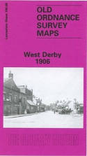
This detailed map covers the West Derby area, NE of Liverpool. Coverage stretches from Lark Hill Lane eastward to Deysbrook Lane; and from Sandfield Park northward to Almond Green.
Features include St Mary's church, West Derby Orphanage, Cheshire Lines Railway with West Derby station, St James church, tramway, Lark Hill, numerous villas (several of them named), Broughton Terrace, Croxteth View, Leyfield Farm, Crown Brewery etc. On the reverse we include a selection of street directory entries, incl Almonds Green, Crosby Green, Hartington Road, Town Row, West Derby Village.
This map links up with sheet 106.04 Croxteth Hall to the north, 106.07 Anfield to the west, 106.12 Knotty Ash to the south.
(Price & availability last checked: July 2023)
In booklists: Alan Godfrey Maps,
In categories: History & Biography, Local Interest,
© News From Nowhere Co-operative Ltd IP24524R 2004-2024 | Privacy policy | Contact | return to top of page